Showing 10 results

collections
1 results with digital objects Show results with digital objects
India
GB 249 T-GED/22/1/1153 · Item · 1882
Part of India: General

'L'Inde Anglaise 1882 d'après le texte de la Nouvelle Géographie Universelle et d'autres documents récents'
[Two copies of the same map]
'Carte dressée par C. Perron sous la direction d'Elisée Reclus'
'Gravé par Erhard [ ... ] Paris'
'Paris Imp. Fraillery [ ... ]'

Author: C[ ] Perron under supervision of Elisée Reclus.

Scale: 1:7,500,000.

Both maps heavily annotated in manuscript in ink by Elisée Reclus. The maps appear to be proof copies.

India
GB 249 T-GED/22/1/1156 · Item · [1912]
Part of India: General

Four pages with maps of India.

'John Bartholomew & Co. Edin[bu]r[gh]'

Anon.

Various scales.

From 'The Citizens Atlas'.

India
GB 249 T-GED/22/1/1152 · Item · [c. 1818]
Part of India: General

'Hindoostan'

Author: Anon.

Published by T. Brown and W. & D. Lizars, Edinburgh.

From 'New Edinburgh General Atlas'.

Scale: 3 inches to 400 miles.

India
GB 249 T-GED/22/1/1154 · Item · 1889
Part of India: General

'Asie Centrale et Inde'

Scale: 1 cm to 100 km.

Anon.

On the reverse, maps of 'Palestine' and 'Indo-Chine et Malaisie'

'Supplément du no 885 du Journal de la Jeunesse du 16 novembre 1889. Feuilee Spécimen de l'Atlas Manuel, prime offerte par le Journal de la Jeunesse a ses Abonnés par l'Année 1890' endorsed on reverse.

India
GB 249 T-GED/22/1/1155 · Item · [1890]
Part of India: General

'Inde Carte 41'
'Gravé par Erhard F[rè]res [ ... ] Paris'
'Imprimè par G. Chamerot'

Anon.

Scale: 1:10,000,000

From Atlas de Gèographie Moderne.

On the reverse, text and diagrams referring to the map and India.

India
GB 249 T-GED/22/1/1159 · Item · No date
Part of India: General

Physical map of India and adjacent countries showing relief of ground.

Scale unspecified.

Anon.

'Box 1st floor' endorsed on reverse in manuscript in pencil.

India
GB 249 T-GED/22/1/1160 · Item · No date
Part of India: General

'India (Northern Sheet) by Keith Johnston F.R.S.E.'
'Engraved, Printed and Published by W. & A.K. Johnston, Edinburgh & London'

Scale: 1:4,457,000

Inset: 'Calcutta and Environs'

From Keith Johnston's General Atlas, plate 33.

Johnston, (Alexander) Keith, the elder, 1804–1871, geographer and cartographer
India
GB 249 T-GED/22/1/1157 · Item · 1916
Part of India: General

'India showing the railways open and under construction on 31-3-1916'
'Published under the direction of Colonel Sir S.G. Burrard, K.C.S.I., R.E., F.R.S., Surveyor General of India, 1916'
'Heliozincographed at the Survey of India Office, Calcutta.'

Anon.

Scale unspecified.

Five insets showing details of railways at 'Jherriahe & Raneegunge Coal Fields', 'Bombay', 'Cawnpore Jn.', 'Madras', 'Ceylon', 'Calcutta', 'Agra'.
Endorsed on the reverse in bottom left corner in manuscript in pencil with a 'Thought diagram' by Patrick Geddes.

India
GB 249 T-GED/22/1/1161 · Item · No date
Part of India: General

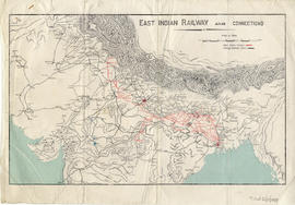
'East Indian Railway and Connections'

Anon.

Scale: 7 inches to 1000 miles

On the reverse (left half) are pencil sketches of valley section and unidentified diagrams.

India
GB 249 T-GED/22/1/1158 · Item · No date
Part of India: General

'India and Ceylon
'Isobars & Winds June' added in manuscript in water colour in top margin.
'George Philipp & Son, London & Liverpool'
'Andrew J. Herbertson' stamped in bottom right corner.

Anon.

Scale: 1 inch to 200 miles